
Research
Publications
2020
Yann CORTIAL. "Synthèse de terrain à l'échelle planétaire". Thèse de Doctorat, Université de Lyon (2020). [Slides (pptx), French]
Abstract: Allowing the real-time exploration of huge, detailed, heterogeneous synthetic terrains remains an unsolved challenge in computer graphics, despite forty years of research. In general, existing methods only handle terrains of limited extent, defined over a planar topology. In this thesis, we explore terrain modeling at maximum-scale, i.e. at planetary scale - a scale which exceeds by four orders of magnitude the extent of the domain of classical terrain synthesis. However, this problem has been largely neglected, only a couple of modeling methods have been proposed in past research. To tackle this challenge, we propose a novel decoupled solution, capable of generating true-to-scale planets. Our architecture takes first into account the geology of terrestrial planets by deploying a guided plate tectonics simulation. This simulation allows the generation of large-scale planetary features such as continents, oceanic relief, islands arcs and mountain ranges. This macroscopic model is then forwarded as an input to an hyper-amplification method capable of producing continuous, detailed real-time views of the terrain. To handle the size of the domain, the procedural amplification method relies on the pre-structuration of the tectonic model, allowing on-the-fly generation of the final detailed model, restricted to the current camera view. The model is produced entirely on the GPU by relying on a massively parallel stochastic subdivision scheme, guided by level-of-detail dependent rules. Overall, our method better handles certain problems tied to previous fractal methods, such as the self-similarity of homogeneous landscapes and the lack of user-control, by producing planets that show more variety, appear more realistic and can be more efficiently designed by artists.
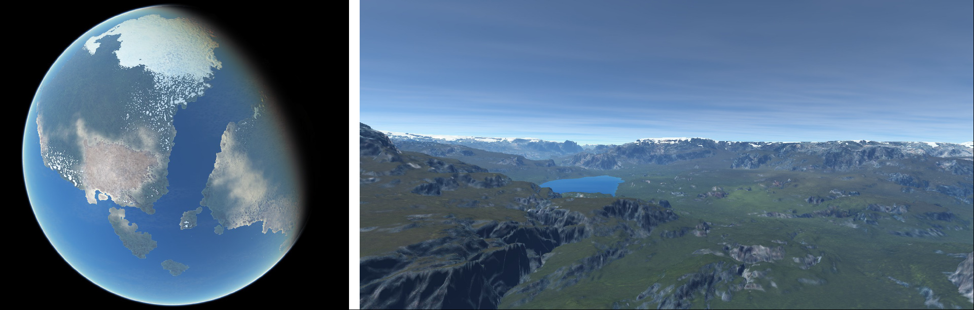
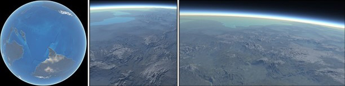
Yann CORTIAL, Adrien PEYTAVIE, Éric GALIN and Éric GUÉRIN. “Real-time hyper-amplification of planets”. In : The Visual Computer (2020), vol 36 (#10) p. 2273-2284
Abstract: We propose an original method for generating planets with a high level of detail in real time. Our approach relies on a procedural hyper-amplification algorithm: a controlled subdivision process that faithfully reproduces landforms and hydrosphere features at different scales. Starting from low-resolution user-defined control maps providing information about the elevation, the presence of large-scale water bodies and landforms types, we apply subdivision rules to obtain a high-resolution hydrologically consistent planet model. We first generate large-scale river networks connected to inner seas and oceans and then synthesize the detailed hydrographic landscapes, including river tributaries and lakes, mountain ranges, valleys, plateaus, deserts and hills systems. Our GPU implementation allows to interactively explore planets that are produced by tectonic simulations, generated procedurally or authored by artists.
2019
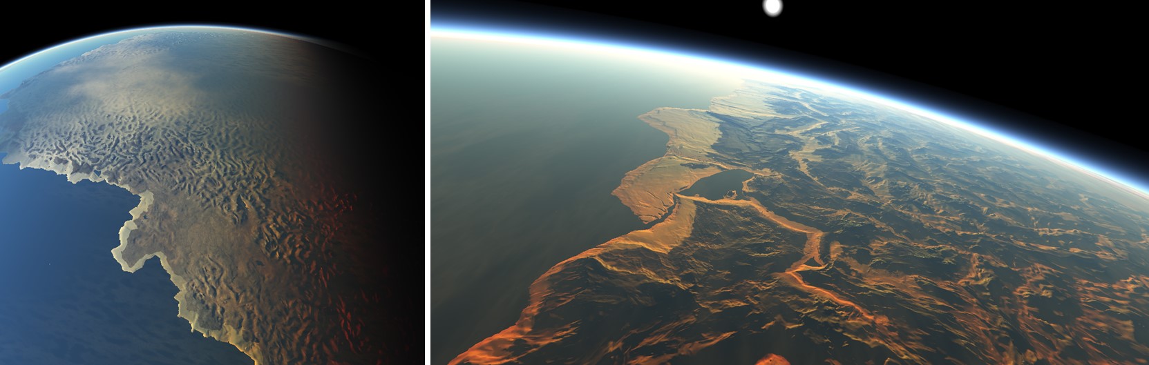
Yann CORTIAL, Adrien PEYTAVIE, Eric GALIN and Eric GUÉRIN. “Procedural Tectonic Planets”. In : Computer Graphics Forum. T. 38. 2. Wiley Online Library. 2019, p. 1-11
Abstract: We present a procedural method for authoring synthetic tectonic planets. Instead of relying on computationally demanding physically‐based simulations, we capture the fundamental phenomena into a procedural method that faithfully reproduces large‐scale planetary features generated by the movement and collision of the tectonic plates. We approximate complex phenomena such as plate subduction or collisions to deform the lithosphere, including the continental and oceanic crusts. The user can control the movement of the plates, which dynamically evolve and generate a variety of landforms such as continents, oceanic ridges, large scale mountain ranges or island arcs. Finally, we amplify the large‐scale planet model with either procedurally‐defined or real‐world elevation data to synthesize coherent detailed reliefs. Our method allows the user to control the evolution of an entire planet interactively, and to trigger specific events such as catastrophic plate rifting.
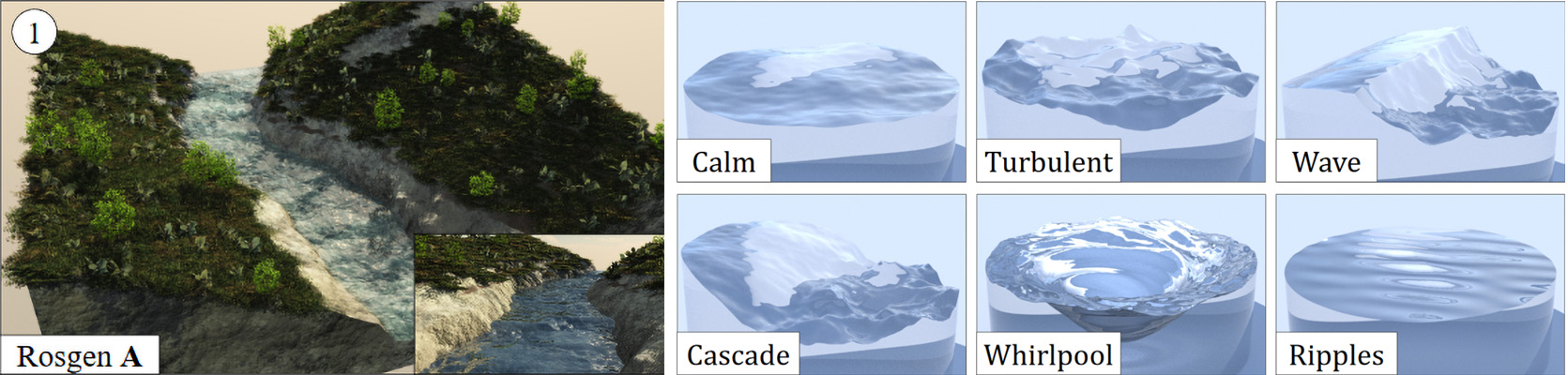
Adrien PEYTAVIE, Thibault DUPONT, Eric GUÉRIN, Yann CORTIAL, Benes BENES, James GAIN and Eric GALIN. “Procedural Riverscapes”. In : Computer Graphics Forum 38.7 (2019), p. 35-46
Abstract: This paper addresses the problem of creating animated riverscapes through a novel procedural framework that generates the inscribing geometry of a river network and then synthesizes matching real-time water movement animation. Our approach takes bare-earth heightfields as input, derives hydrologically-inspired river network trajectories, carves riverbeds into the terrain, and then automatically generates a corresponding blend-flow tree for the water surface. Characteristics, such as the riverbed width, depth and shape, as well as elevation and flow of the fluid surface, are procedurally derived from the terrain and river type. The riverbed is inscribed by combining compactly supported elevation modifiers over the river course. Subsequently, the water surface is defined as a time-varying continuous function encoded as a blend-flow tree with leaves that are parameterized procedural flow primitives and internal nodes that are blend operators. While river generation is fully automated, we also incorporate intuitive interactive editing of both river trajectories and individual riverbed and flow primitives. The resulting framework enables the generation of a wide range of river forms, ranging from slow meandering rivers to rapids with churning water, including surface effects, such as foam and leaves carried downstream.
2018
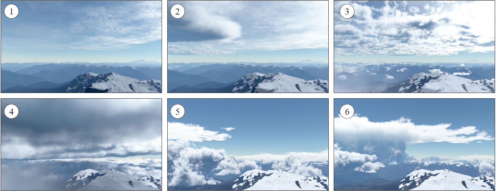
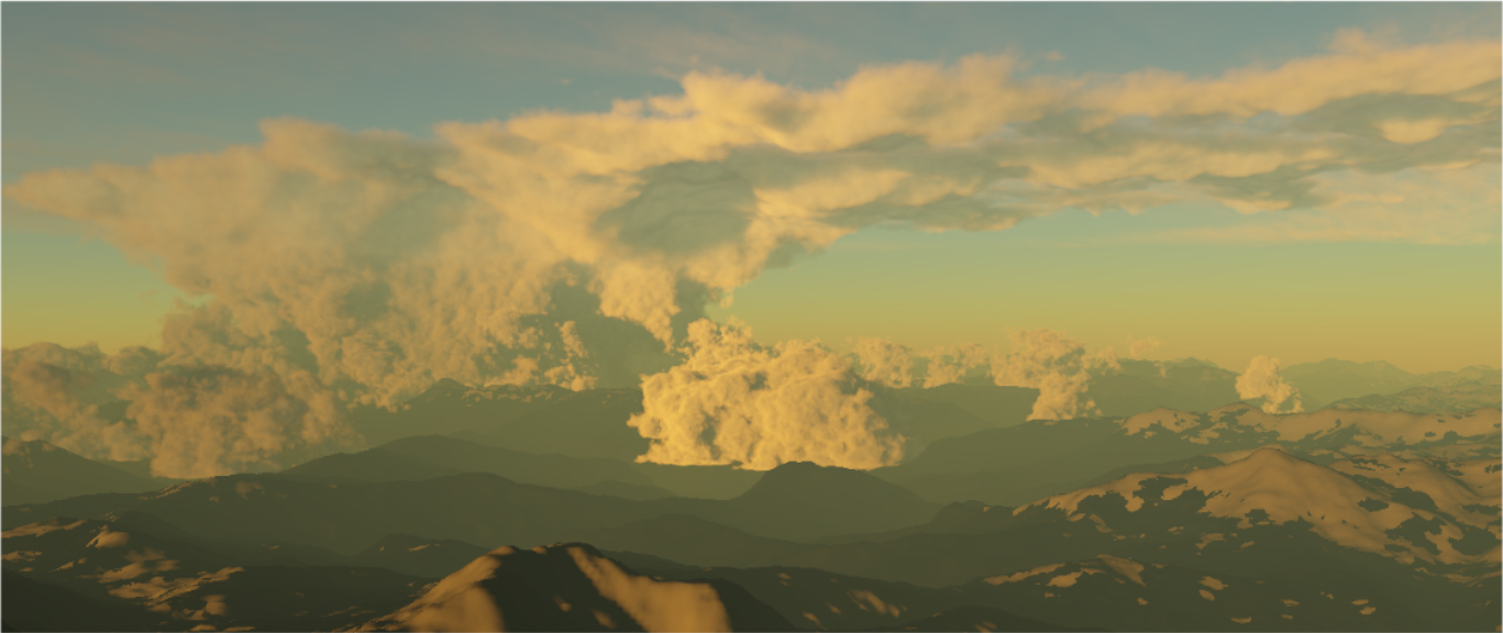
Antoine WEBANCK, Yann CORTIAL, Eric GUÉRIN and Eric GALIN. “Procedural cloudscapes”. In : Computer Graphics Forum. T. 37. 2. Wiley Online Library. 2018, p. 431-442
Abstract: We present a phenomenological approach for modeling and animating cloudscapes. We propose a compact procedural model for representing the different types of cloud over a range of altitudes. We define primitive‐based field functions that allow the user to control and author the cloud cover over large distances easily. Our approach allows us to animate cloudscapes by morphing: instead of simulating the evolution of clouds using a physically‐based simulation, we compute the movement of clouds using key‐frame interpolation and tackle the morphing problem as an Optimal Transport problem. The trajectories of the cloud cover primitives are generated by solving an Anisotropic Shortest Path problem with a cost function that takes into account the elevation of the terrain and the parameters of the wind field.
2017
Yann CORTIAL, Antoine WEBANCK, Eric GUÉRIN, Adrien PEYTAVIE and Eric GALIN. “Modélisation procédurale de nuages multigenre”. In : Journées Françaises d’Informatique Graphique (j.FIG). Rennes, France, oct. 2017
Background
November 12th, 2020 - PhD Defense
Title: "Terrain Synthesis at the Planetary Scale".
Most of the defense was streamed on youtube (in French), https://www.youtube.com/watch?v=JMsR0JetGQk.
Jury: Loïc Barthe, Marc Daniel, Céline Roudet, Eric Galin, Eric Guérin and Adrien Peytavie.
2017-2020 - PhD
October 2017, I received a public grant for a PhD. The thesis was to be under the supervision of Eric Guérin and
Adrien Peytavie,
researchers at LIRIS-CNRS, two experts in their domain, namely terrain modeling and natural sceneries modeling.
Consequently my research topic was also to be related to terrain modeling, albeit with a specific approach as I was interested in
maximum-scale terrain modeling, ie., planetary terrains.
2017 - Graduation
September 2017, I received a Master's degree in computer science, with a specialty in computer graphics and programming, from Université Claude Bernard Lyon 1.
I ranked number one in the second year (the year of specialization), as well as in 4 out of the 6 semesters of the previous Bachelor curriculum.
I had the great opportunity to take a 6 months research internship at LIRIS-CNRS (Lyon, France). Under the co-supervision of Eric Galin and Eric Guérin, I worked on
large cloudscapes modeling.
2012 - Back to Studying
In 2012 I enrolled back in the local university of Lyon (France), after a long medical hiatus (years long), in search for a better future.
I chose to study math & computer science - but, at the age of 37 and without much experience apart from some personal coding projects,
I knew I had to start all over again, so this was me stepping carefully into the first year of the Bachelor syllabus.